<AREA ...>SHAPESHAPE=CIRCLE | SHAPE=DEFAULT |
<AREA ...>SHAPESHAPE=CIRCLE | SHAPE=DEFAULT |
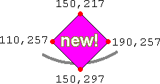
Looking for info on how to make an image map?See our tutorial How to Make an Image MapSHAPE=POLY indicates that the area is some type of polygon (i.e. a geometric shape consisting of s straight sides). For a polygon, each pair of coordinates in COORDSFor example, suppose the corners of the polygon are located at these coordinates:
We would set the coordinates with code like this:
<AREA
HREF="new.html" ALT="New!" TITLE="New!"
SHAPE=POLY COORDS="150,217, 190,257,  150,297,  110,257">
which gives us the diamond shape in this map: 
|